By Hanna Tuoriniemi | HAF intern
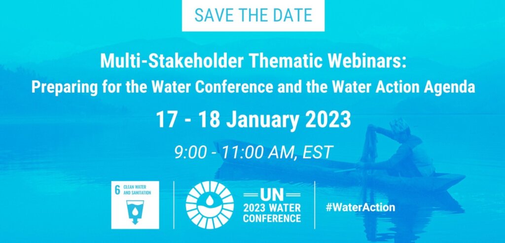
On January 18th, the United Nations preceded their 2023 Water Conference to be held in March with a multi-stakeholder thematic webinar entitled Preparing for the Water Conference and the Water Action Agenda. The event proved to be an effective catalyst for discussions to be held during the Water Conference, with a theme of multi-stakeholder action echoed throughout the webinar. After opening remarks, the conference was divided into three separate panels for: Water for Climate, Resilience, and Environment, Water for Cooperation, and
On January 18th, the United Nations preceded their 2023 Water Conference to be held in March with a multi-stakeholder thematic webinar entitled Preparing for the Water Conference and the Water Action Agenda. The event proved to be an effective catalyst for discussions to be held during the Water Conference, with a theme of multi-stakeholder action echoed throughout the webinar. After opening remarks, the conference was divided into three separate panels for: Water for Climate, Resilience, and Environment, Water for Cooperation, and lastly Water Action Decade. This article will break down the three panels and summarize their implications for the 2023 Water Conference.
Theme One: Water for Climate, Resilience, and Environment:
Mr. Matthews, the executive director for AGWA started off this segment as the first panelist speaker. Matthews explained that the world must expect for climate transformation and be willing to put water at the forefront of mitigation efforts. Matthews made a unique analogy to compare climate transformation to diabetes and not cancer, explaining that it comes down to management efforts as opposed to eliminating this “disease”. After his speech, the moderator, Elisabeth Bernhardt gave an incredible synopsis by explaining that “water is not the victim; it is part of the solution”.
The next speaker, Judith, a department head at Deltares, explained the idea of the water bubble. Those who are in water-related industries can work to make change; however, we must break this boundary to ensure that we have global cooperation towards this crisis. Kaspersma also identified three useful elements to be able to measure change: foundational, institutional, and gamechangers. Each identification increases the level of impact that the change produces, however it is essential to recognize that change on any level is important.
Kathryn, a Senior Water Advisor for WaterAid, was the next speaker within this segment. Pharr emphasized that 80% of used water ends up being recycled back into the land untreated. There are simply not enough initiatives and collaboration occurring right now to combat this issue, along with water security threats. Pharr’s speech was a call to action for us to boost our collaboration efforts.
The last speaker for this segment, Dalton, is the director of the Global Water Programme. Dalton emphasized the idea of action, as there are currently many wonderful ideas to increase sustainable development without enough traction to commence. Following the previous water conference, Dalton shared his dissatisfaction with a lack of monitoring of actions and movements that were taking place. Therefore, Dalton expressed the importance of not only monitoring the progress made after the Water Conference, but also to share and educate others on what is working to meet the goals and agenda set during the conference.
To summarize this segment, there is an emphasis on effective collaboration that will lead to meaningful results for individuals, institutions, communities, and the world as a whole.
Theme Two: Water for Cooperation:
The first speaker for the second segment was Shomy Chowdhury, the founder of Awareness 360. Chowdhury began her segment with a powerful and tragic anecdote. Her mother passed away due to issues with water sanitation, which was a heartbreaking catalyst for her to begin working in the water sanitation sector. Chowdhury’s powerful story shows the most devastating way that water sanitation issues can impact a family. There must be change to prevent similar tragedies in the future, which is exactly what Chowdhury’s inspiring work is looking to improve. During the segment, Chowdhury emphasized the fact that solutions must be implemented in a way that focuses on cultural context and involves all stakeholders, including the younger generation.
Martinez, a representative of the Indigenous Informal Reference Group on Indigenous Peoples and Water Issues, highlighted the importance of including all stakeholders in the fight for a better future. Martinez emphasized that indigenous groups have technologies to help with water solutions that are currently not being utilized. Indigenous groups also are the keepers of 80% of the world’s biodiversity. Therefore, the Water Conference must ensure that there is a space for Indigenous communities to share their perspectives and solutions. Throughout the segment, Martinez’s message of including all groups to be able to share their voice shined and proved to be a significant factor for generating the highest quality recommendations and initiatives.
The next speaker was CLLR. Nikiwe, the Executive Mayor of Dr. Kenneth District Municipality in South Africa. Num emphasized the idea of collaboration and cooperation being nonnegotiable for creating positive impact. This cooperation should begin within the household through education and continue throughout institutions and on a country-wide level. Societies should be a major catalyst for action and should therefore be made aware of how they can make a positive difference.
The last two speakers of the segment on cooperation were Nicolás and Christain, who both brought in valuable information from their careers on how to build water resilience. Wertheimir is the co-founder and CEO of WaterPlan, which collaborates with Fortune 500 companies to build mitigation strategies for water-related issues. Wertheimir began his career as a doctor who treated water-borne illnesses and has since devoted his life to finding effective water solutions through data. Wertheimir advocates for the usage of technology to foster new solutions, which could be a powerful tool as data collection becomes more and more prevalent.
Christian, the Global Division Director for Climate Adaptation of Ramboll Group, highlighted water as a key strategy for urban development. Nielsen advocated for cities to be a main focus of the Water Conference, as water action is heavily influenced by users in city areas. Nielsen also emphasized the future by developing the next generation of bioengineers and water professionals.
The Second Theme of the thematic webinar emphasized that the fight for water resilience must include all stakeholders; young and old alike, from all cultures and backgrounds. With this cooperation and collaboration, more innovative solutions will be designed and implemented to reach our water goals.
Theme Three: Water Action Decade:
The final theme for the webinar began with Carolina Tornesi Mackinnon, the President of the World Youth Parliament for Water. MacKinnon raised a valuable claim that one week of the Water Conference in New York City will not end the water crisis. Instead it is the “start of the end”. This indicates that the Water Conference will be a great opportunity to share ideas and gain momentum for water solutions, but will begin a long lasting framework that will have to be implemented and improved upon as years come. MacKinnon also raised the fact that all stakeholders can join in on the action raised through the conference and can be a part of the fight. This commitment will be powerful and will, as MacKinnon explained, breathe life into the initiatives discussed this spring in New York.
Hiroki, the Coordinator of the High Level Experts and Leaders Panel on Water and Disasters and a Professor at GRIPS of Japan brought in an idea similar to Wertheimir about data transformation capabilities. Water data could be a valuable source of information in deciding on how to approach the fight against the water crisis. Hiroki also explained how data could encourage the finance industry to see how water problems and solutions relate to its field.
The last speaker of the webinar was Olcay Unver, a Professor of Practice at Arizona State University and member of the Water Policy Group, focused more on a governing aspect of the water crisis and how it relates to the climate, solution, and biodiversity. The goals that Unver presented were emphasized as tangible, meaning that they will be helpful to highlight during the Water Conference. Unver’s goals include reflection of what has already been put into action, declarations of new action-creating pledges, the authorization of all meetings to include how water can be included into outcomes and objectives, the inclusion of water quotas in portfolios of financial communities, and the removal of barriers that prevent innovation for the water crisis.
Theme Three of the thematic webinar explained a multitude of perspectives on how the 2023 Water Conference can create lasting and beneficial agendas for combatting the water crisis.Martinez, a representative of the Indigenous Informal Reference Group on Indigenous Peoples and Water Issues, highlighted the importance of including all stakeholders in the fight for a better future. Martinez emphasized that indigenous groups have technologies to help with water solutions that are currently not being utilized. Indigenous groups also are the keepers of 80% of the world’s biodiversity. Therefore, the Water Conference must ensure that there is a space for Indigenous communities to share their perspectives and solutions. Throughout the segment, Martinez’s message of including all groups to be able to share their voice shined and proved to be a significant factor for generating the highest quality recommendations and initiatives.
The next speaker was CLLR. Num, the Executive Mayor of Dr. Kenneth District Municipality in South Africa. Num emphasized the idea of collaboration and cooperation being nonnegotiable for creating positive impact. This cooperation should begin within the household through education and continue throughout institutions and on a country-wide level. Societies should be a major catalyst for action and should therefore be made aware of how they can make a positive difference.
The last two speakers of the segment on cooperation were Nicolás Wertheimir and Christain Nielsen, who both brought in valuable information from their careers on how to build water resilience. Wertheimir is the co-founder and CEO of WaterPlan, which collaborates with Fortune 500 companies to build mitigation strategies for water-related issues. Wertheimir began his career as a doctor who treated water-borne illnesses and has since devoted his life to finding effective water solutions through data. Wertheimir advocates for the usage of technology to foster new solutions, which could be a powerful tool as data collection becomes more and more prevalent.
Christian, the Global Division Director for Climate Adaptation of Ramboll Group, highlighted water as a key strategy for urban development. Nielsen advocated for cities to be a main focus of the Water Conference, as water action is heavily influenced by users in city areas. Nielsen also emphasized the future by developing the next generation of bioengineers and water professionals.
The Second Theme of the thematic webinar emphasized that the fight for water resilience must include all stakeholders; young and old alike, from all cultures and backgrounds. With this cooperation and collaboration, more innovative solutions will be designed and implemented to reach our water goals.
Theme Three: Water Action Decade:
The final theme for the webinar began with Carolina, the President of the World Youth Parliament for Water. MacKinnon raised a valuable claim that one week of the Water Conference in New York City will not end the water crisis. Instead it is the “start of the end”. This indicates that the Water Conference will be a great opportunity to share ideas and gain momentum for water solutions, but will begin a long lasting framework that will have to be implemented and improved upon as years come. MacKinnon also raised the fact that all stakeholders can join in on the action raised through the conference and can be a part of the fight. This commitment will be powerful and will, as MacKinnon explained, breathe life into the initiatives discussed this spring in New York.
Hiroki, the Coordinator of the High Level Experts and Leaders Panel on Water and Disasters and a Professor at GRIPS of Japan brought in an idea similar to Wertheimir about data transformation capabilities. Water data could be a valuable source of information in deciding on how to approach the fight against the water crisis. Hiroki also explained how data could encourage the finance industry to see how water problems and solutions relate to its field.
The last speaker of the webinar was Olcay Unver, a Professor of Practice at Arizona State University and member of the Water Policy Group, focused more on a governing aspect of the water crisis and how it relates to the climate, solution, and biodiversity. The goals that Unver presented were emphasized as tangible, meaning that they will be helpful to highlight during the Water Conference. Unver’s goals include reflection of what has already been put into action, declarations of new action-creating pledges, the authorization of all meetings to include how water can be included into outcomes and objectives, the inclusion of water quotas in portfolios of financial communities, and the removal of barriers that prevent innovation for the water crisis.
Theme Three of the thematic webinar explained a multitude of perspectives on how the 2023 Water Conference can create lasting and beneficial agendas for combatting the water crisis.
By Aleksander Esmann | HAF intern
By Yossef Ben-Meir | President
Project reports on GlobalGiving are posted directly to globalgiving.org by Project Leaders as they are completed, generally every 3-4 months. To protect the integrity of these documents, GlobalGiving does not alter them; therefore you may find some language or formatting issues.
If you donate to this project or have donated to this project, you can receive an email when this project posts a report. You can also subscribe for reports without donating.
Support this important cause by creating a personalized fundraising page.
Start a Fundraiser